Michaela's Landscape
The work and thoughts of a Landscape Student
21 March 2013
5 March 2013
The Missing Concept
So, a few days ago I posted Concepts and Masterplans but there was no concept.
Originally, I think I was trying to weave together my 3 developments. The weaving was a mental exercise. But then it evolved into this idea of intersecting connections made by different landscapes elements. Although I could well be post-rationalising a spot of procrastination.
So Green is the doorstep landscape, Blue is the River and Black is the Urban Fabric. The nice thing about a weave is; when the strands are separated they're formless but weaved together they form a strong structure.
Next I started looking at other 3 stringed methods. The one I liked most is the fish tail plait, where one strand ties the other two together. Translated on my site this is the River bringing landscape and urban fabric together.
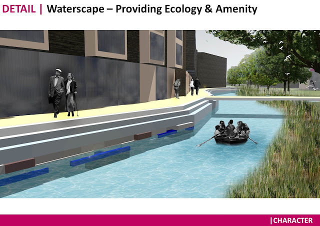
Moving into the realm of actuality: My aim is to use (for the most part) the historical template of farmland irrigation ditches to create a linked swale network connected to the River Stour. Therefore providing a linked, sustainable landscape.
 |
| Historical Map showing Highlighted Waterways |
3 March 2013
Concepts and Masterplans
Last Monday was the second Crit of my final MA Project. I've posted before (about the project) but I haven't actually explained what and why my project is or about. I think its time to correct this..
My project is about connecting the lost Medieval (more Industrial) quarter, Wincheap, to Canterbury City Centre. Wincheap formed during the middle ages along one of the major routes into Canterbury. Since then the area has expanded with housing to the south and Commercial/Industrial warehouses to the North. The latter area gives Wincheap something of an undesirable air.
As my course is Landscape Assessment and Design, I need some developments to look at. Mine consist of 3 separate developments that are hypothetically being consolidated.
In 2007 Canterbury City Council commissioned masterplanning for regeneration of Development 1: Wincheap Industrial Estate. The Plans only got so far but now (in the hypothetical student world) following the recent (again hypothetical as the developments are nearly completed) submission of planning on Development 2: The Tannery & Development 3: Bingley Court, the council wish the company who are planning Development 3 to head all three Developments as a whole (so I am assuming that Developer No.3 has purchased the rights to Development No.2). Issues the council wish the developer to tackle are:
My project is about connecting the lost Medieval (more Industrial) quarter, Wincheap, to Canterbury City Centre. Wincheap formed during the middle ages along one of the major routes into Canterbury. Since then the area has expanded with housing to the south and Commercial/Industrial warehouses to the North. The latter area gives Wincheap something of an undesirable air.
In 2007 Canterbury City Council commissioned masterplanning for regeneration of Development 1: Wincheap Industrial Estate. The Plans only got so far but now (in the hypothetical student world) following the recent (again hypothetical as the developments are nearly completed) submission of planning on Development 2: The Tannery & Development 3: Bingley Court, the council wish the company who are planning Development 3 to head all three Developments as a whole (so I am assuming that Developer No.3 has purchased the rights to Development No.2). Issues the council wish the developer to tackle are:
- The connectivity, particularly for the pedestrian, of Wincheap to Canterbury
- Connections across all three developments into the doorstep countryside; namely Hambrook Marshes, Whitehall Meadows and Westgate Parks
- The character of the development and it's relationship to Canterbury's Townscape character; this relates both to Massing, Street configuration and Building aesthetics.
- The sustainability of the development, particularly in relation to SUDs for flood AND drought mitigation.
- The benefits on the local economy. The developments should be mixed with a view to attracting tourists and to engagement with local colleges and/or universities.
So first off the existing developments need to be analysed using diagrams:
20 February 2013
Lille Workshop Pt.2
Also at the initial stages of the Lille trip was a site visit:
As said in a previous post the site is a derelict industrial paper works. The surrounding area is a mix of cheap housing and industrial warehouses.
After a day or so our small groups presented their work.
My small group concentrated on the idea that the Hellemmes site was a catalyst for change. We had a spark igniting at the central node, spreading out through synapses. Our spark was the instigation of a cultural hub into the site. This was to act as something to bring local people together and entice outsiders, tourists in.
After the presentations our group joined with another group to form a final larger group.
  |
| Some of the new group |
11 February 2013
Lille Workshops Pt.1
 This week I've travelled to Lille as a part of 20 or so individuals from Greenwich university. We will be working together to brainstorm ideas for an area in the Hellemmes. The site is post industrial and currently unused. Initially we're in small groups to create concepts and strategies.
Ideas begin to flow:
Initial pin-up of ideas:
7 February 2013
Diagrams and New Perspectives
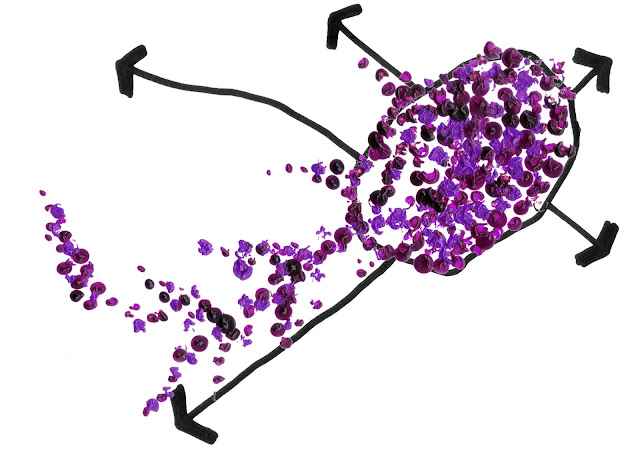
It's been a long while since posting. During my unapologetic absence I've started an MA in Landscape Architecture. Its final project time dealing with Assessment and Design. Assessment means diagrams and my favourites are shown below. The site is Canterbury and how it might be reconnected to it's Medieval quarter (read mostly industrial bizarrely) known as Wincheap. Canterbury is contained with in the circular city wall and Wincheap stretches out in a South Westerly direction.
 |
| Existing Situation: Paint splodges indicate areas with strong cultural or heritage links |
 |
| Developing Situation: New Developments do nothing to tap into the culture of Canterbury |
 |
| Proposed Situation: A way of reintegrating the Wincheap Quarter is to provide strong links with the city's heritage |
Location: London
Canterbury, Kent, UK
Subscribe to:
Posts (Atom)


